The Past and Future of GIS: An Unforgettable NYS Geospatial Summit
by: Rich Quodomine, Carol Zollweg, and Alan Leidner
 |
 |
 |
 |

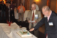
On a rainy and chilly evening on the night of Tuesday October 23rd, nearly two hundred New York State GIS professionals filled the amphitheater like main floor of the Welch Allyn Lodge just a few miles from the fog enshrouded Village of Skaneateles, south of Syracuse. The center of our attention was a tall, elegant, elderly, white bearded gentleman with a cane standing in front of a large cake decorated with a single lit candle and inscribed with the words Celebrating 50 Years of GIS.
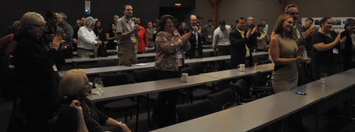
 Following the lead of Bill Johnson and Bruce Oswald the assembled multitude burst into the singing of Happy Birthday to honor the Golden Anniversary of the founding of GIS and the man, Dr. Roger Tomlinson, the father of GIS, who had made it all possible. Then Dr. Tomlinson, wielding a large kitchen knife, cut the cake, making a long line across the white icing, as if he were splitting a parcel with a new boundary line; Cadastral data at its tastiest.
 Prior to the cake cutting, we were treated to the film “Data for Decision,” made in 1964, in which a young Dr. Tomlinson explains how computers can be used to solve geographic problems. For those of us who went to grammar school in the 1970s and 1980s, the film will feel like the time the teacher turned the lights out and we looked forward to a science film on an actual projector. For those readers under 30, it involves something called film, and reels, and … aw, forget it. It’s some great history and it certainly will make you appreciate how far the discipline has come. In a scant 50 years, this discipline has gone from a government-based, highly focused mapping tool to a powerful cross-disciplinary system approach to thinking spatially and displaying geographic information, from maps to tables to three-dimensional images. GIS has changed, whether the broad public appreciates it or not, the way we all think.


Dr. Tomlinson
Dr. Tomlinson and his team at the Canada Land Inventory Agency were the first to digitize spatial data and computerize its analysis thereby creating the first Geographic Information System and initiating an entirely new profession. For those in attendance it was awe-inspiring to be in the presence of Dr. Tomlinson and to honor him for a lifetime of achievement. Dr. Tomlinson, equal parts intellect, wit and warmth, stayed with us through Wednesday relating stories about those early days and generously sharing his wisdom about how best to design and implement geospatial systems. He stated repeatedly that above all else he took pleasure in the companionship of fellow GIS’ers.
The Summit Itself
On the formal day of the Summit, Wednesday, October 24th, content is presented as a series of topics, rather than multiple tracks with several presentations occurring at once. In other words, everyone attends the same sessions; however, we attend for many different reasons. We attend to learn, to network, and to be inspired. This year we saw not only how where GIS is headed, but how GIS got started.
 Dr. Tomlinson spoke again to Geospatial Summit attendees about the wonder and possibilities of the GIS profession. He showed how GIS is used in a myriad of professions, from Archaeology to Zoology. He was especially encouraging to students, assuring them of the growth of GIS in the years to come.
 Dr. Sinton, Director Spatial Curriculum and Research, also echoed Dr. Tomlinson on the importance of spatial thinking and the need to develop these skills at the K-12 level. She spoke about spatial literacy and the importance of making sure that K-12 teachers have these skills to impart to their students

 Justin Barton, CyArk, a corporation that uses GIS to preserve and image monuments, gave us some fascinating looks at our past. Recently, religious radicals have destroyed a number of images they consider idolatrous, yet with the LiDAR “photographs” taken before their destruction, an organization like CyArk can help to restore lost works. A powerful use of LiDAR and 3D imaging (even literally under a carved stone nose at Mount Rushmore) can mean so much to the preservation of art and architecture. (TED Talk)
 Google, not to be outdone, opted to join the forum with use of… Google technology. Specifically, using Google Hangout, Ed Parsons joined us from halfway around the world. Google continues to maintain some of the leading geospatial imagery used by the non-GIS person. In fact, most people don’t know that Google Maps, or transit routes, or any number of functions that they deliver are based on GIS. To the average consumer, they’re a combination of functional and cool. This is something we GIS professionals are going to need to recognize: as GIS technologies permeate everyday use, people won’t necessarily see the GIS, just as one might pick up the phone and not realize the need of an electrical engineer to produce it.
 Perhaps the most thought-provoking presentation was Professor Roel Vertegaal’s presentation on Human-Machine interface. Dr. Vertegaal’s work focuses on things like network-fiber paper computers, ultra light computational papers that can process not with a keyboard, but a simple bend of this special “paper.” Going forward, one can even create a globe and interact with a paper globe, plotting directions in a real sense of space-time. Imagine if you could touch a paper, have it form a rough globe in front of you, and then plot directions to the NECTAR conference in the Azores, and perhaps then use Google’s ubiquitous search capacity to book a flight, hotel, and some points of interest.
 To finish the day, John Bacus from SketchUp, explained that the driving force behind SketchUp is ease of use. There are many 3D programs out there but they are very difficult to use. SketchUp is designed to be simple, yet powerful, demonstrated by the 3D Warehouse that contains millions of building models. He emphasized that the driving force in development of new features in SketchUp is never to make it more complex than necessary. In addition, he assured us the acquisition of SketchUp by Trimble will not change its pricing structure and that SketchUp will remain free, and SketchUp Pro will remain affordable; that they will continue to support their core users and everyone else; that they will support third-party development partners; and will continue to make the software faster.
The NYS GIS Association is proud to have organized such a well-received event and congratulates the summit committee on a job well done. Many thanks to Austin Fisher, Bruce Oswald, Jason Baum, Christa Hay, Dale Morris, Elisabeth DeGironimo, John Barge, Bill Johnson, Jim Gilmer, Julie Tolar, Katherine Kiyanitsa, Lindi Quackenbush, and Todd Nelson; and many thanks to the presenters and attendees. The Geospatial summit reminded us just how it is exciting to be a part of a dynamic, changing discipline that has a strong past, and more importantly, a vibrant future.

More pictures (Facebook)
